Game changing satellite imagery for forestry.
Planet Labs users leverage real time imagery to increase operational visibility and save time updating data and driving to tracts. We help organizations navigate Planet’s products, automate and integrate them into your business for immediate operation impact.
-
See What Others Can't
When you’re juggling multiple timber sales, contractors and employees, time is at a premium. Real time, up to date imagery provides actionable information on operations so that work doesn’t slip between the cracks.
- Not sure if the timber is still there and don’t have the time for the drive to the tract? With Planet Labs one can pull up imagery from yesterday and get an answer.
- Watch all forest activities with less trips, quantify remaining acres to harvest without having to walk the perimeter.
- Significant cost savings over imagery from drones or fixed wing aircraft.
- No file handling or data management needed to monitor the progression of site prep or harvests.
- Flexible subscription model for organization wide imagery access.
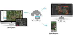
 Planet Labs Imagery is streamed directly to any application or device.
 -
Advantages for Real Time Imagery from Planet Labs
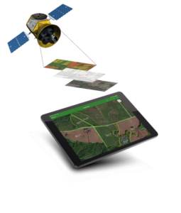
Getting a recent aerial or satellite image for a tract can be painful and time consuming. Drones take too much time, tasking a fixed wing aircraft is cost prohibitive and searching the web often turns up short. To top it off, these traditional mechanisms for acquiring imagery involve handling huge files and even processing. There’s a new approach with Planet Labs and it’s truly revolutionary – read below to learn what we’re talking about.
- Planet Labs imagery is integral to the use of Cloud Native technology we encourage across our client base. What this means to foresters is ease of use and little to no file management. See this post from Planet on why Cloud Native is what makes amazing technology like Planet possible.
- Do you want to spend time searching, downloading and managing imagery files? Probably not – and this is why so many foresters look to Google and other web apps for imagery. The problem is that the imagery one finds is often out of date and not easily combined with other map layers.
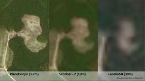
- Multiple resolutions from 3.7m (Daily Monitoring) to 0.5m (SkySat) are available for various needs – and one can access each in a browser or in ArcGIS Pro. See below comparison of medium resolution imagery with free options often used in forestry.
- Imagery distribution is built in since Planet Labs streams to GIS software or a web browser – this means everyone in your operations can see imagery without having to post, publish or distribute huge imagery files.
-
What We bring to the table
Planet is a relatively new product with tons of amazing features and product options. Would your rather figure it out on your own, or work with a partner who knows how to apply Planet tools to your business?
- We’re Planet Labs imagery experts with a deep understanding of forestry and GIS. This means we help you navigate the options, and strategy which makes imagery work with the rest of your data and systems.
- We provide improved workflows for the use of imagery in forestry operations and its use in updating business data.
- We handle high resolution SkySat tasking requests for you in minutes so you don’t have to.
- Optionally we can implement automation tools to make your imagery even more powerful. .
- On call tech support so you can stay focused on forestry.
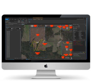
Planet Labs in ArcGIS Pro – searchable for use in a map with stands and tracts.
-
Get your Digital Edge!
Redefining Forest Technology is more than talk, it’s about rethinking forest technology from the ground up. To compete in the digital age – where information needs to be available wherever work is being done – requires new approaches.
- Success with forestry technology doesn’t happen any more than a house gets built without a plan. Planet Labs is a core part of digitally enabling operations to save time, get answers to every day operational questions and eliminate risks.
- Yesterdays tools and approaches no longer meet the information needs of today’s workforce – real time imagery is part of a strategy to save time, make vital data updates, reduce complexity and provide teams a consistent picture of forest assets.
- Planet Labs imagery often accompanies our Web GIS for Forestry solution to increase transaction velocity so staff get answers fast and from anywhere work is being done.