Maintaining and improving habitat for sensitive species like the red-cockaded Woodpeckers requires timely and analysis ready data.
Habitat recovery planning is an intricate process requiring field data collection and collaborations between foresters and biologists. However, older technologies like the RCW Matrix and spreadsheets are slow, un-reliable and often yield inconsistent outputs.
As a leading technology provider with in house biologists managing red-cockaded Woodpeckers (RCWs) we provide organizations “Forage Factor” which is an enterprise grade geospatial toolset which automates digital processes from the field to the office, making habitat work simpler, more consistent and to create defensible management plans.
-
Background
Red-cockaded woodpecker (Picoides borealis) is a federally listed endangered species endemic to open, mature and old growth pine ecosystems in the southeastern United States (RCW Recovery Plan, 2nd Edition, US FWS). Both private and public organizations put significant resources into both managing existing RCW habitat or expanding populations, both of which involve forest management and specific silvicultural treatments.
The following sections provide more information on how Forage Factor supports organizations in their work with RCWs by significantly improving the repeatability of analysis and saving significant labor time across numerous aspects of habitat analytics.
DOWNLOAD THE FORAGE FACTOR ONE PAGE FACT SHEET.
-
The Challenge
Technology has advanced dramatically over the past 20 years. However, many of the tools used in natural resources have not evolved to meet the needs of the modern workplace.
- Forest inventory is not easily shared with biologists and habitat analysis is out of date as soon as inventory is updated.
- Field data can take numerous steps to be made useful.
- Biologists are often working with copies of forest inventory rather than the latest version.
- File based data on a single PC makes sharing results with other stakeholders difficult.
- Software like the RCW Matrix is not supported, is difficult to use and may not operate in modern computing environments.
- Present methods cost time, make it challenging to produce consistent results and to promote an up to date view of habitat efforts.
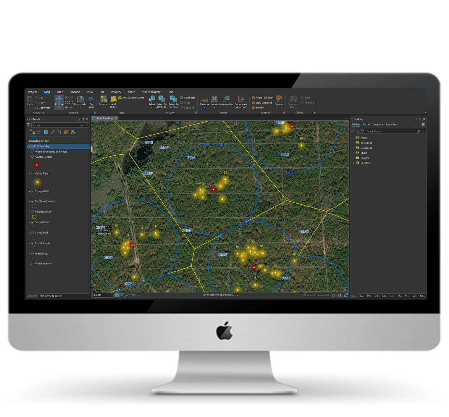
ArcGIS Pro with RCW Cavity Trees, Clusters and Partition analysis generated by Forage Factor
-
Forage Factor - Analytics Automation
Teams charged with RCW management have the opportunity to improve outcomes through more predictable and reliable digital processes. Our strategy provides a real time view of program key performance measures from cavity tree status to analytical reporting.
- A Single Version of the Truth for RCW habitat and recovery eliminates conflicting ‘versions’ of program information.
- End to end automation of workflows without files – habitat suitability is reported in minutes after cavity trees or forest inventory changes.
- Single entry point of data entry eliminates data handling in multiple software and files.
- A real time view of all program metrics from basal area, habitat suitability, mid story composition, forage acres and recommendations such as burns or mid-story removal.
- Anyone can make updates to cavity trees on a single data source from any device for a real time view of program performance.
- All maps, data and analysis can be viewed on any device from anywhere work is being done.
- Spatially based across all components and data to include cavities, forest inventory, partitions and existing management units.
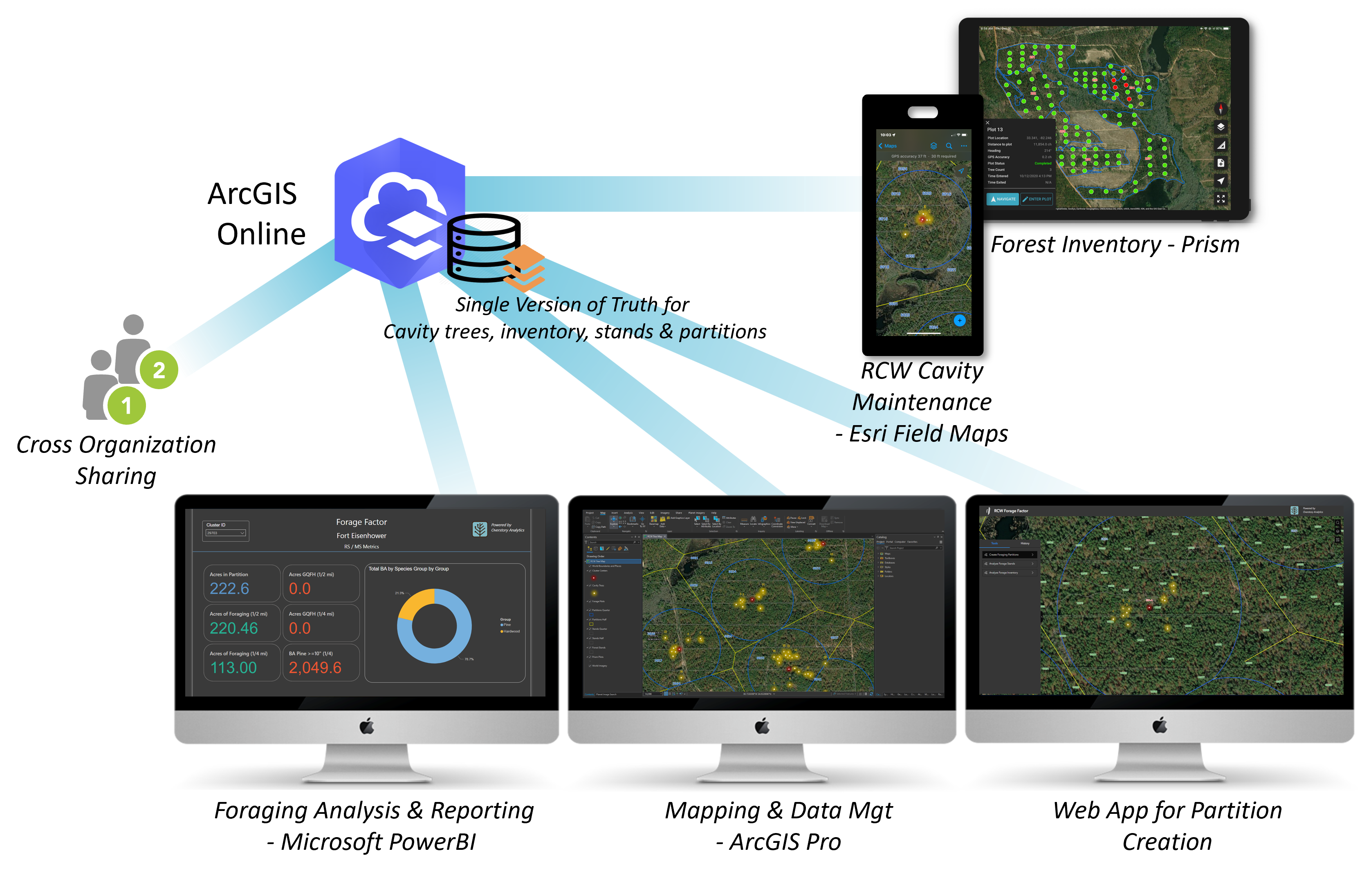
Forage Factor Architecture and ApplicationsForage Factor uses forest inventory data created and maintained by Prism.
Learn About PrismReach out to us: redefine@soforest.com
-
Built to Last
In the modern workplace, information must be easy to find and use while being secure. As an Esri Business Partner working with numerous large agencies, we provide tools which meet IT standards and which are designed to function reliably for years to come.
Forage Factor is:- Built on Esri’s ArcGIS which is approved and in use in most agencies.
- Leverages ArcGIS and Microsoft resources already in place in most organizations.
- Real time output of Managed Standard, Recovery Standard and basal area DBH breakouts – at a stand and partition level.
- Measures suitable and Good Quality Foraging Habitat (GQFH) acres for 1/4 and 1/2 mile partitions.
- Minimal to no software installs required, just ArcGIS and Microsoft office.
- Supports large inventory programs with regularly updated rolling inventories which feed RCW analysis – see image below showing an example which uses Prism to maintain a real time forest inventory which also serves RCW analytics.
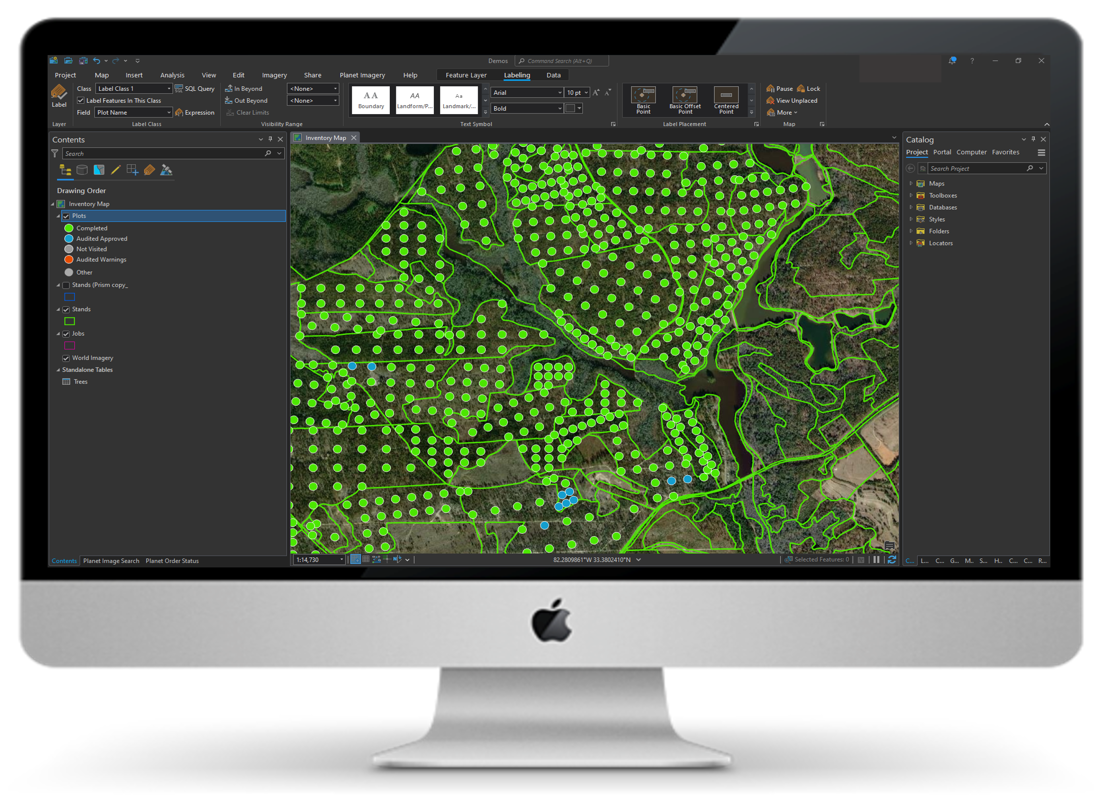
Large Inventory Program Supporting Forestry and Habitat Decision Making – Displayed in ArcGIS Pro.